Find Us
Rooted in the Hills
Our parcel sits on Champagne Ridge in Kiserian, Kajiado County — elevated terrain with sweeping views of the Ngong Hills escarpment and rich red-soil farmland.
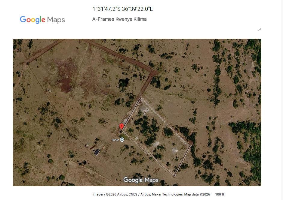
Current satellite view — A-Frames Kwenye Kilima at 1°31′47.2″S 36°39′22.0″E, Champagne Ridge, Kiserian. Plot boundary, stone retaining wall, and neighbouring fenced plot visible. Imagery ©2026 Airbus, CNES / Airbus, Maxar Technologies. Exact parcel boundaries subject to official survey documentation from the Kenya Land Commission.
Champagne Ridge
Our 2-acre parcel (Plot No. Kajiado/Olchoro-Onyore/45032) is officially titled and zoned for hospitality and agricultural use, with both our Change of Use Permit (Q3 2026) and Kajiado County Development & Building Plan Approval (October 2026) secured.
Region
Champagne Ridge, Kiserian
County
Kajiado County, Kenya
Landmark
Ngong Hills Escarpment
Nearest Town
Kiserian (~5 km)
Google Plus Code
FMC4+3C, Olooloitikosh, Kenya (1°31′47.2″S 36°39′22.0″E · Davis Road, off Magadi Road)
What's Nearby
Well Connected, Beautifully Removed
Close enough to Nairobi for convenience, far enough from the city for peace.
Ngong Hills
~8 kmIconic ridge with panoramic Rift Valley views
Kiserian Town
~5 kmLocal market, services, and transport hub
Nairobi CBD
~35 kmApproximately 45–60 min drive via Ngong Road
JKIA Airport
~55 kmJomo Kenyatta International Airport
Karen & Langata
~20 kmUpscale Nairobi suburbs and wildlife conservancies
Maasai Mara
~250 kmWorld-famous wildlife reserve, ~4 hr drive
Directions
How to Get Here
From Kiserian Magadi Road — follow these landmarks to reach us on Davis Road, Champagne Ridge.
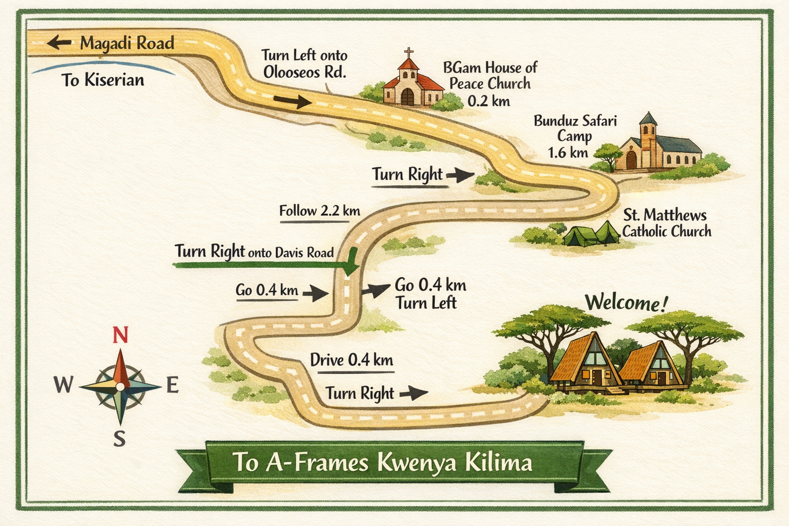
Illustrated route map — landmarks and distances are approximate.
Starting Point
Corner Baridi — Kiserian Magadi Road / Oloseos Road
GPS / Google Maps Pin: Search FMC4+3C, Olooloitikosh, Kenya or enter coordinates -1.52978, 36.65611 for turn-by-turn navigation directly to Davis Road.
Turn left onto Oloseos Road
Corner Baridi junction·0.19 km to BGam Church
Continue past BGam House of Peace Church
BGam Church on your right·0.2 km
Continue — pass Tania Centre on your left
Good Hope Academy on your left·0.5 km from Corner Baridi
Continue — pass Bunduz Safari Camp on your right
St. Matthews Catholic Church on your right·0.85 km — 1.2 km
Continue — pass Ilmasin Primary School & AIC Church on your right
Car Yard / Garage on your left·0.565 km — 0.4 km
Turn right onto Davis Road
Poultry Farming Farm on your right (0.45 km down Davis Rd)·0.42 km on Davis Road
Turn left — pass Windscape Water Supply Company on your right
Windscape Water Supply on right·0.76 km — then 0.45 km
Turn right, then immediately turn left
Follow 0.05 km, then 0.8 km·0.14 km — 0.35 km
Turn left — destination on your left
A-Frames Kwenye Kilima — Davis Road, Champagne Ridge·0.05 km
The Parcel
Site Plan Overview
Our 2-acre parcel on Champagne Ridge is designed to balance luxury accommodation, working farmland, and community gathering spaces.
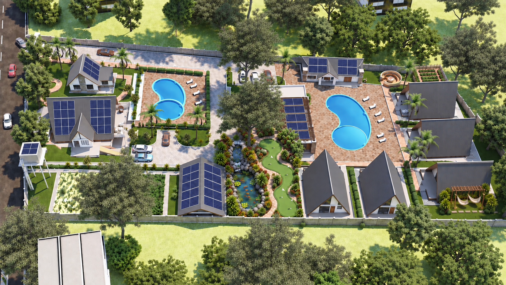
Site plan is a projected design. Final layout subject to permitting and construction phases.
Secure Your Place on the Hill
Flagship Cottage 1 breaks ground in May 2027, with public Founders Club enrollment opening upon completion in late 2027 so prospective members can tour the finished retreat in person. Join our private waitlist today for First Look invitations and build updates.